ARCHIVE
Restoration
of Hope Valley Old
Guard Station Restoration ProjectSilver
King Creek will not be poisoned
Preserving
Hope Valley's Basque Oven
Forestdale
Creek
Old
Guard Station Restoration ProjectSilver
King Creek will not be poisoned
Preserving
Hope Valley's Basque Oven
Forestdale
Creek
The Winter
Recreation Plan for Eastern Alpine County
New
Rules proposed for off-road vehicles(2004)
Lawsuit
filed to restore Pleasant Valley Trail Access
Restoration
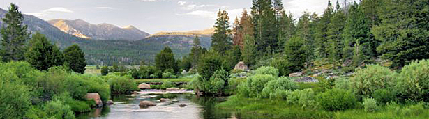
of Hope Valley
A diverse group of volunteers has been actively involved as Stewards
working on the Hope Valley Meadow Restoration Project, a project funded
by the Sierra Nevada Conservancy, National Fish & Wildlife Foundation,
and the Bella Vista Foundation. Its goal is to draft a permit-ready
plan to restore this highly visible and well-known meadow. The group
is helping with stream flow monitoring, data entry, and photo monitoring.
The Hope Valley meadow is threatened by hydrologic alteration, and the
West Fork Carson River has serious erosion along its banks. The overall
goal of this restoration project is to restore the full range of services
that this ecosystem provides: natural water storage, flood attenuation,
cooling and filtering of water, aquatic and riparian habitat, and recreational
activities.
Initially, there is a targeted assessment of the meadow’s attributes
to determine its hydrologic and ecological function; this information
is used to complete possible designs for a meadow restoration plan.
Or, this information could suggest that there is no restoration project
that its benefits are worth its cost.
The goal of baseline monitoring is to capture changes in Hope Valley’s
meadow condition over time and to have a record of information used
for the design of a restoration project. Baseline monitoring includes
parameters that characterize the meadow surface water hydrology ,the
condition of vegetation communities, and the use of the meadow by wildlife
for habitat.
To date the Stewards’ work has consisted mostly of the evaluation
of the meadow’s surface water hydrology, including the compilation
of a record of stream flow over time. This can be determined by measuring
the area of water at a given location and multiplying that by the velocity,
or how fast the water is moving – giving a measured discharge.
Measuring the discharge of water and correlating it with the height
of water at several locations develops a relationship of the two and
the stream’s flow.
The monitoring also consists of data loggers that can measure the change
in water height (pressure) at regular intervals (every 15 min), recording
this data to be downloaded periodically. Data loggers also collect water
temperature and specific conductivity readings. There are currently
three data loggers along the West Fork Carson River in Hope Valley.
Old Guard Station
Restoration Project
Sarah Green
The Alpine Watershed Group (AWG) has been working with Alpine County,
the Friends of Hope Valley and various other community partners since
2005 to plan a stream restoration project at the site of the former
U.S. Forest Service Guard Station along Markleeville Creek. This site
has been subjected to significant and repeated flooding over the years.
The flood wall which was constructed in the 1930’s to prevent
flooding has only resulted in accelerated water flows causing erosion,
stream incision and stream bank failures downstream.
The Markleeville Creek Restoration Project will reestablish the natural
state of the stream and prevent further property damage as a result
of flooding. The project will improve stream side habitat by removing
the flood wall and re vegetating the area. This restoration effort will
provide various community benefits including utility improvements and
public access for recreation such as walking paths, interpretive signege,
picnicking and possibly parking. Partners involved in this project include
Alpine County, Carson Water Sub conservancy District, Chamber of Commerce,
Friends of Hope Valley, Markleeville Public Utility District and the
Washoe Tribe.
The project is currently in the design phase of the planning process.
Funding for this project has been provided by the California Department
of Conservation, the Carson Water Sub conservancy District and the Sierra
Nevada Conservancy. AWG and the County have also collaborated on a grant
application which would allow the County to acquire the land for restoration
purposes.
back
to top
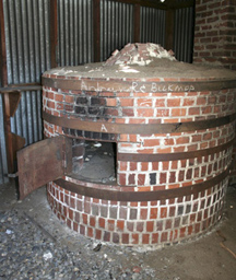 PRESERVING
HOPE VALLEY'S BASQUE OVEN
PRESERVING
HOPE VALLEY'S BASQUE OVEN
In the early
1900’s Fred Dangberg started a sheep camp in Hope Valley. Seven
bands of sheep (2,000 sheep per band) spent the summers there, each
tended by a sheepherder. Most sheepherders in the west at that time
were Basque, expert sheep tenders who were immigrating to the U.S. from
their homelands in northern Spain and southwestern France in search
of work.
The Dangberg sheep camp headquarters in Hope Valley, still visible still
along Highway 89 partway up the Luther Pass grade, included a Basque
tender man named Jesus. It was Jesus who in the 1930s was chiefly responsible
for the building of the large, authentic bread oven we now hope to preserve.
To preserve
this valued treasure the Friends of Hope Valley has been working with
the Alpine County Historical Society on a project to relocate the oven
to the Historical Society’s museum in Markleeville. This historic
oven is a valued part of the history of Alpine County and the west.
It reminds us of the role Basque sheepherders played in the history
of the Sierra Nevada; preserving it honors their memory.
back to top
Forestdale
Creek
Friends of Hope Valley believes that if all facets of the Proposed Project
were implemented that it would have a net benefit to the non-motorized
community. The following pairs of quiet use and snowmobile opportunities
are presented to show the balancing.
Quiet-use opportunity. The Forestdale Creek area up
to Forestdale Divide will be closed to snowmobiles when there is sufficient
snow at the Blue Lakes SnoPark for snowmobile use. This typically is
from early or mid-December through early or early or mid-April. Therefore
most of the winter season it will be closed. Prior and after the closure
period snowmobiles will still be restricted to the road through the
Forestdale Creek area.
Snowmobile opportunity. Improve accessibility of the
Monitor Pass area to snowmobiles and open portions of the area that
are currently closed to snowmobiles. This will include creating a staging
area at Loope Canyon, which is above the current road closure point.
This will also afford better access for non-motorized users wanting
to access the Heenan Lake area that will remain closed to snowmobiles.
The south side of Monitor Pass area will remain closed to snowmobiles
when deer are present.
Quiet-use opportunity. The north side (actually it
is west) of Highway 88 from Carson Pass to Picketts Junction will be
closed to snowmobile use with one exception. That means Crater Lake,
Scotts Lake,Red Lkae Peak and Stevens Peak will be off-limits to snowmobiles.
The exception is that there will be a route on a road through the area
that connects the Armstorng Pass area with the lands in Hope Valley
south of Highway 88. This is to allow snowmobilers to ride from South
Lake Tahoe to Blue Lakes. The route through the area will get minimum
grooming. The purpose of the grooming is to define the route but not
create a raceway.
Snowmobile opportunity. Improved snowmobile staging
at Centerville. Centerville is located at the eastern winter closure
of Highway 4. Snowmobiles currently park here but use is low because
there is a section of Highway 4 (called the Flintstones) that is avalanche
prone much of the winter. An old road that bypasses the Flintstones
would be repaired where it was washed out. Highway 4 from Centerville
to Ebbetts Pass may be groomed for snowmobile use.
Quiet-use opportunity. Create a parking area at Red
Corral on Highway 88 to increase access to quiet-use terrain north and
south of Highway 88. Improved parking at Picketts Junction (Burnside
Road). These two parking areas may become SnoParks. Shoulder-parking
on Highway 88 will be prohibited over a 4-mile stretch except for several
turnouts that allow additional access to the north and south sides of
Highway 88.
Snowmobile opportunity. Additional parking, including
overnight parking, at the Blue Lakes SnoPark.
Snowmobile opportunity. The pruning of trees and installation
of markers along the primitive road from Blue Lakes to Highway 4. This
divides the Mokelumne Wilderness into two pieces. Snowmobilers occasionally
use this route. These improvements are intended to help motorists stay
within the non-wilderness corridor. This snowmobile route will not be
groomed.
Proposed
Action needs details
Friends of Hope Valley 's review of the NOPA revealed that the document
needs more details. Therefore it is extremely important that you take
the time to write the Forest Service to express the need for improvements
to the description of the Proposed Project.
Back to top
Winter
Recreation Plan
The Winter Recreation Plan for Eastern Alpine County now is in the hands
of the Forest Service and is presently going through NEPA funding procedures
while input and coordination with other agencies is being developed.
This project would improve winter recreation experience for both motorized
and non-motorized users in eastern Alpine County.
Friends of Hope Valley, in conjunction with other user groups, individuals
and agencies, participated in the formulation of this plan, and indeed,
our Board President, Debbi Waldear, was instrumental in the genesis
of this plan. Essentially, this plan would delineate areas of use, address
parking and camping issues as it seeks to enhance the experience for
all winter users by presenting a good balance of opportunities.
During the recent comment period, Friends urged the Forest Service to
act with all possible speed on the implementation of this plan as well
as the need for enforcement once the plan is in place. This winter’s
light snowpack and motorized growth has resulted in chaotic use of Hope
Valley by snowmobiles. Wilderness incursions in the Forestdale Creek
headwaters have been frequent, and the concentration of use by machines
is resulting in environmental degradation as well as unacceptable noise
levels. Snowmobiles are now being seen in areas where they’ve
never been seen before.
Although the initial scoping comment period is over you can still let
the Forest Service know how you feel. Ask them to act quickly and stress
the need for designated areas for motorized and non motorized users.
Express outrage that motorized users are violating wilderness boundaries.
New
Rules proposed for off-road vehicles
On July 15
the Forest Service announced proposed new rules for managing off-road
vehicles on National Forest lands. The rule would require vehicles to
stay on designated routes. While long-overdue, the proposal is weak,
unfunded and includes no timetables for completing the designation process.
Comments on
the proposed rule are due by Sept. 13, 2004. Please make your members
aware of the proposal by circulating or posting on your website the
attached Action Alert and sample comment lettter. If you have any questions,
please call Karen Schambach at 530-333-1106. Thanks!
Back to top
LAWSUIT
FILED, WITNESSES SOUGHT TO RESTORE
PLEASANT VALLEY TRAIL ACCESS
Former Pleasant Valley trail users asked to come forward
South Lake Tahoe, CA – A lawsuit has been filed in the United
States District Court for the Eastern District of California on behalf
of the Friends of Hope Valley (FOHV) in an effort to reassert the public’s
right to access Pleasant Valley in Alpine County, CA. Past trail users
are being sought to appear as witnesses in the case against a private
landowner who has shut off access to Pleasant Valley’s trails
since 1999.
Pleasant Valley is a beautiful meadow south of Lake Tahoe that for more
than 100 years had served as a primary access point into Alpine County’s
high country, including the Pacific Crest Trail and the Mokelumne Wilderness
Area. Access to Pleasant Valley was gated shut in 1999 by private land
owners who no longer wished to have hikers, anglers, and other recreationalists
cross their land in order to reach the federal public lands beyond.
In the years that followed, Friends of Hope Valley (FOHV) worked to
persuade the Dressler family to voluntarily reopen access to the Pleasant
Valley trails for public use, but despite years of attempts to find
a resolution, this gateway to public lands remains closed. With no other
corrective recourse available, the FOHV has engaged San Francisco law
firms Shute, Mihaly & Weinberger LLP (SMW) and Kerr & Wagstaffe
LLP and has filed a lawsuit to reopen the trail.
Says Matthew Zinn of Shute, Mihaly and Weinberger, ”This case
represents a clear violation of the public’s right to have access
to trails where there is a long history of use by the public.”
The public’s right to access public trails, even where they pass
through otherwise private land, is firmly established in California
state law. Any land in California that was open to public access for
five continuous years before 1972 cannot lawfully be closed to public
access. There is ample evidence demonstrating many decades of public
use of the trails, according to the Friends of Hope Valley.An
nual
Work Party Day
| Hope
Valley needs your Help!
Decisions
of public officials threaten the scenic beauty of Alpine County.
The winter repose of the Sierra, free from the gas driven mechanized
vehicle, is vanishing.
Become
an Activist of the Friends of Hope Valley. We need a battalion of
interested individuals to attend critical meetings and write letters.
Be willing to attend meetings held during the week in Alpine County.
Give us your email address.
We will alert you to important meetings and provide background information
for issues of interest to you that will be discussed. Alpine County's
policy makers must hear our voice.
We must be proactive, rather than just
reactive!
|
rridoreis.anl.gov/documents/index.cfm
print
version